The Adventure of Bisoke Hike: Conquering Rwanda's Volcanic Gem and Its Trail Magic
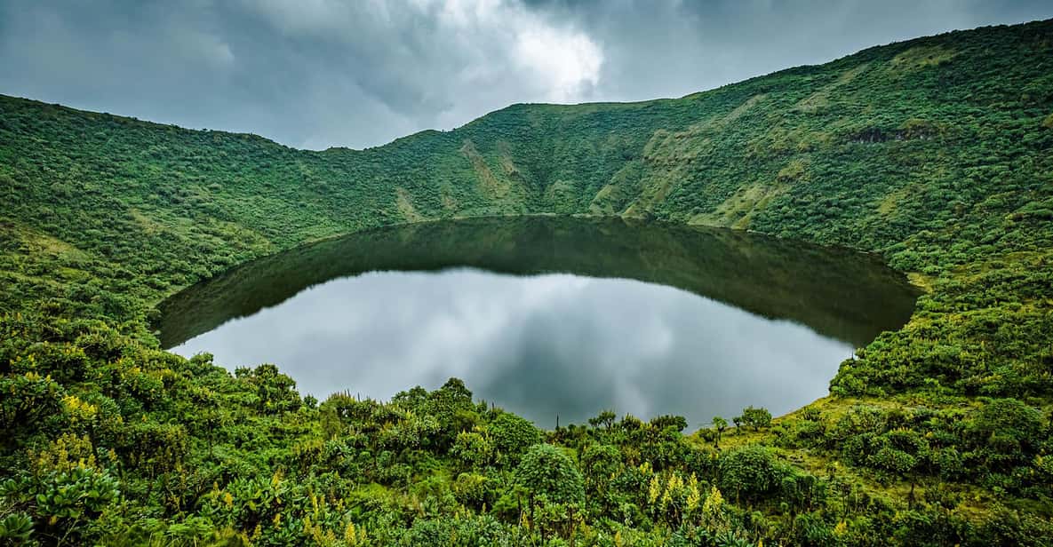
Mount Bisoke is one of Rwanda’s most beautiful and approachable volcanoes. It sits in the Virunga Mountains inside Volcanoes National Park, right on the border with the Democratic Republic of the Congo. It’s a classic dormant volcano covered in thick forest, bamboo, and misty slopes.The name “Bisoke” is said to come from a local word connected to water—fitting, because its most famous feature is the wide, turquoise crater lake right at the top. On a clear day the water mirrors the sky perfectly, framed by steep crater walls. It’s easily one of the most photogenic spots in the Virungas.
The trail to the peak is considered one of the more manageable volcano hikes in the region. You start through lush bamboo forest and montane woodland, then climb steadily on sometimes muddy and slippery paths. The reward is that stunning crater lake and sweeping views of the surrounding volcanoes.Most people complete the round trip in a single day. It’s steep in places and the altitude can make you feel it a little, but it doesn’t demand multi-day effort or extreme technical skills. Many hikers hear or even glimpse mountain gorillas or golden monkeys along the way.
The trail to the peak is considered one of the more manageable volcano hikes in the region. You start through lush bamboo forest and montane woodland, then climb steadily on sometimes muddy and slippery paths. The reward is that stunning crater lake and sweeping views of the surrounding volcanoes.Most people complete the round trip in a single day. It’s steep in places and the altitude can make you feel it a little, but it doesn’t demand multi-day effort or extreme technical skills. Many hikers hear or even glimpse mountain gorillas or golden monkeys along the way.
Practical SideYou need a permit to hike Bisoke, arranged through the Rwanda Development Board or a trusted local operator. A guide (and often an armed ranger) comes with it for safety and navigation.The dry seasons bring firmer trails and better summit views—rain turns the path into thick, slippery mud pretty quickly. Good boots, rain gear, layers, snacks, and plenty of water are must-haves. Porters are available if you want help carrying your daypack.Why People Love ItBisoke gives you the full volcanic experience—dense forest, possible primate encounters, wide views across the Virunga chain, and that unforgettable crater lake—without needing several days or extreme fitness. Lots of visitors pair it with gorilla trekking: one day tracking gorillas, the next day hiking Bisoke. It’s a perfect combination for seeing Rwanda’s wild side.If you’re coming to the Land of a Thousand Hills and want a beautiful, rewarding day in the mountains, Bisoke should definitely be on your list.
.jpeg)


Comments
Post a Comment